GIS服务托管服务
mapplat 也可以用来简单的托管一些GIS方面的数据服务
警告
该页面内的内容针对的是开发人员或者运维人员, 如果你是非技术人员可以忽略
mapplat 怎样托管瓦片(tile)集合
目前 mapplat 只能托管mbtiles集合 , mbtile 里数据不限坐标系, 投影, 切图参数等, 支持任意坐标投影, 只要你请求mbtile的投影信息和mbtiles里的一样即可
警告
mbtiles 一般有我提供, 如果你也会制作mbtiles文件你可以制作好了然后放到 mapplat 里进行托管
/[path]/mappplat/serverconfig.js里开启 mbtiles 选项
//serverconfig.js
//其他配置项

mbtiles: true;- 重启 mapplat
node --max-old-space-size=80000 --tls-min-v1.0 index- 将你的 mbtiles 文件放到 mapplat 的
/[path]/mappplat/store/mbtiles文件夹下 或者使用代理服务数据管理页面进行数据上传
- 假设你的文件名叫
hello.mbtiles - 那么你的 tile 请求地址为:
[ip]:[port]/mapplat/common/mbtiles/hello/{z}/{x}/{y}
//[ip]:[port]/mapplat/common/mbtiles/hello/{z}/{x}/{y}
//mapplat为可选项,如果你的服务地址必须要mapplat,那就加上,否则去掉,和你部署mapplat的方式有关,默认mapplat是没有[mapplat]的,但是如果你是做一些反向代理是么的可能就需要加上去
//such as:https://mapplat.z7z7z7.cn/mapplat/common/mbtiles/countries-raster/{z}/{x}/{y}mapplat 怎样托管矢量瓦片(vectortile)集合
目前 mapplat 只能托管mbtiles集合, mbtiles里必须存放 gizp 后的 mvt 数据
警告
mbtiles 一般有我提供, 如果你也会制作mbtiles文件你可以制作好了然后放到 mapplat 里进行托管
/[path]/mappplat/serverconfig.js里开启 mbtiles 选项
//serverconfig.js
//其他配置项

mbtiles: true;- 重启 mapplat
node --max-old-space-size=80000 --tls-min-v1.0 index- 将你的 mbtiles 文件放到 mapplat 的
/[path]/mappplat/store/vt-mbtiles文件夹下 或者使用代理服务数据管理页面进行数据上传 - 假设你的文件名叫
hello.mbtiles - 那么你的 tile 请求地址为:
[ip]:[port]/mapplat/common/vt-mbtiles/hello/{z}/{x}/{y}
//[ip]:[port]/mapplat/common/vt-mbtiles/hello/{z}/{x}/{y}
//mapplat为可选项,如果你的服务地址必须要mapplat,那就加上,否则去掉,和你部署mapplat的方式有关,默认mapplat是没有[mapplat]的,但是如果你是做一些反向代理是么的可能就需要加上去
//such as:https://mapplat.z7z7z7.cn/mapplat/common/vt-mbtiles/%E5%90%B4%E6%B1%9F%E5%8C%BA_polygon/12/3424/1675mapplat里怎样托管shp文件?
警告
shp 只支持 WGS84(EPSG:4326) 或者 CGCS(EPSG:4490) 坐标系经纬度投影的数据, 其他的投影坐标的数据文件不支持
将你的 shp 的
zip压缩包文件放到 mapplat 的/[path]/mappplat/store/shpfiles文件夹下 或者使用代理服务数据管理页面进行数据上传shp数据源是用来为其他服务服务, 比如矢量切片, WMTS等,其没有直接请求接口
DANGER
shp 文件集合请用zip压缩, 且只能用zip压缩
mapplat 怎样将 geojson 文件托管为矢量切片(vectortile)服务
警告
geojson 只支持 WGS84(EPSG:4326) 或者 CGCS(EPSG:4490) 坐标系经纬度投影的数据, 其他的投影坐标的数据文件不支持
将你的 geojson 文件放到 mapplat 的
/[path]/mappplat/store/tile-geojson文件夹下 或者使用代理服务数据管理页面进行数据上传假设你的文件名叫
hello.geojson那么你的 tile 请求地址为:
[ip]:[port]/mapplat/common/vt-tile/hello/{z}/{x}/{y}
DANGER
服务端匹配你的文件请求规则: 优先匹配 tile-geojson 里的文件,如果匹配不到,将去匹配 shpfiles 里的文件
//[ip]:[port]/mapplat/common/vt-tile/hello/{z}/{x}/{y}
//mapplat为可选项,如果你的服务地址必须要mapplat,那就加上,否则去掉,和你部署mapplat的方式有关,默认mapplat是没有[mapplat]的,但是如果你是做一些反向代理是么的可能就需要加上去
//such as:https://mapplat.z7z7z7.cn/mapplat/common/vt-tile/sihongwater/{z}/{x}/{y}- 如果想一个瓦片内请求多个geojson图层,你可以用
,来分割多个图层, 比如:wujiangroad,wujiangbuilding
请求地址如下:
//[ip]:[port]/mapplat/common/vt-tile/wujiangroad,wujiangbuilding/{z}/{x}/{y}mapplat里怎样托管WFS服务
操作步骤:
/[path]/mappplat/serverconfig.js里开启 wfs 选项
//serverconfig.js
//其他配置项
wfs: true;- 重启 mapplat
node --max-old-space-size=80000 --tls-min-v1.0 index- 将你的 geojson 文件放到 mapplat 的
/[path]/mappplat/store/wfs-geojson文件夹下 或者使用代理服务数据管理页面进行数据上传
警告
geojson 只支持 WGS84(EPSG:4326) 或者 CGCS(EPSG:4490) 坐标系经纬度投影的数据, 其他的投影坐标的数据文件不支持
- 数据的请求接口地址定义
[ip]:[port]/mapplat/common/wfs/:fileName/:lnglats
| 参数 | 说明 | 举例 |
|---|---|---|
| filename | 你的geojson文件名 | shanghai |
| lnglats | 经纬度坐标串 | 120,31 |
TIP
关于经纬度串参数如下:
// 点,经度和纬度用 ,
const lnglats = '120,31';
//线,经纬度用 ;
const lnglats = '120,31;122,32;........';
//面,和线一样,唯一的区别就是首尾的坐标要一样,表示闭合(ring)
const lnglats = '120,31;122,32;........;120,31'- 假设你的文件名叫
hello.geojson, 那么你的 服务 请求地址为:[ip]:[port]/mapplat/common/wmts/hello/120,31
- 业务一般的业务代码为:
//查询wfs图层的数据
function query(lnglats) {
    fetch('http://ip:port/common/wfs/shanghaipoi/' + lnglats).then(res => res.json()).then(geojson => {
        const overlays = YY.GeoJSON.toGeometry(geojson);
        vectorLayer2.addOverlay(overlays);
    })
}

//绘制工具
const drawTool = new YY.DrawTool(map, function(e) {
    const overlay = e.geometry;
    vectorLayer2.addOverlay(overlay);
    let lnglats = (overlay.getLngLats ? overlay.getLngLats() : overlay.getLngLat());
    //圆
    if (overlay instanceof YY.Circle) {
        const geojson = overlay.toGeoJSON();
        lnglats = geojson.geometry.coordinates;
    }
    //经纬度数组格式化成经纬度字符串
    const lnglatStr = YY.GH.arrayToStr(lnglats);
    console.log(lnglatStr);
    query(lnglatStr);
});
DANGER
服务端匹配你的文件请求规则: 优先匹配 wfs-geojson 里的文件,如果匹配不到,将去匹配 shpfiles 里的文件
mapplat里怎样托管动态wmts服务?
操作步骤:
/[path]/mappplat/serverconfig.js里开启 wmts 选项
//serverconfig.js
//其他配置项
wmts: true;- 重启 mapplat
node --max-old-space-size=80000 --tls-min-v1.0 index- 将你的 geojson 文件放到 mapplat 的
/[path]/mappplat/store/wmts-geojson文件夹下 或者使用代理服务数据管理页面进行数据上传
警告
geojson 只支持 WGS84(EPSG:4326) 或者 CGCS(EPSG:4490) 坐标系经纬度投影的数据, 其他的投影坐标的数据文件不支持
- 假设你的文件名叫
hello.geojson, 那么你的 tile 请求地址为:[ip]:[port]/mapplat/common/wmts/hello/{z}/{x}/{y}/3857或者[ip]:[port]/mapplat/common/wmts/hello/{z}/{x}/{y}/4326
DANGER
服务端匹配你的文件请求规则: 优先匹配 wmts-geojson 里的文件,如果匹配不到,将去匹配 shpfiles 里的文件
shp datasource test
- 瓦片的请求接口地址定义
[ip]:[port]/mapplat/common/wmts/:fileName/{z}/{x}/{y}/:epsg
| 参数 | 说明 | 举例 |
|---|---|---|
| filename | 你的geojson文件名 | shanghai |
| epsg | 坐标投影参数 | 3857 / 4326 |
怎样加载服务?
yymap 里直接创建个 TileLayer 就可以了, 当然其他的引擎也可以加载,不限制yymap, 比如leafletjs
   const tileLayer = YY.LayerLookup.createTileLayer('https://mapplat.z7z7z7.cn/mapplat/common/wmts/shanghai/{z}/{x}/{y}/3857', {
       maxBounds: [
           [-180, -90],
           [180, 90]
       ],
       // debug: true,
       minZoom: 4,
       // preview: getAssetPath() + 'images/3.png'
   }, {
       code: 'EPSG:3857'
   });
   map.addBaseLayer(tileLayer);
shanghai wmts test
shanghai wmts custom style by leafletjs
怎样动态传样式
在瓦片请求地址里携带你的样式参数即可, 如果不传服务端将采用默认配置的样式
//服务端默认的样式
const DEFAULTSTYLE = {
    polygonFill: '#6691BD',
    polygonOpacity: 1,

    lineColor: '#000000',
    lineWidth: 1,
    lineOpacity: 1,

    markerFile: 'data:image/png;base64,iVBORw0KGgoAAAANSUhEUgAAACAAAAAgCAYAAABzenr0AAAAAXNSR0IArs4c6QAAA7dJREFUWEfFll2ME1UUx/9nptPuhkUTlkQjLMIquj7wgDMlrlF80Wh0JcEE4pNIO7ewUSO86KPG8A4GzWpndtUHH8SoiYBZEj8iRjB2ukr4MhoqLGFVoiKwcddOp8fMlMFuO53OdIncPnTmzjnn/zvnnntzCdd50HXWRyyAL/jlxKmJqSwzD0mE1cxYAoYDojMAFwHar2v5d+IkFRnAtHI6mHeAcFOYAIHOEtFLGfXNt6KARAIwi2I3GM9GCXjVhvGanjaea+fTFsAsiN2gmOK+agSIUICx4pbNVa6ONWZRGl+Gk++tnDN9z4sT6B240JSwRFImbDlCAUat3CSD+9yoM+d78OO7q/DPtNSyqkp3FZIM3L7hOBYsveTZuT2R1fLLWjm1BDCt3CaA3/YdD7/wELrkhd7r5b/K3j+7P2ZPRqL/QnX1zmDNjs/qNOnpVrsjBEDsAbDBj3JweAi39N/gvU6VLqHsVGBXKqh6AEBCktGdTF4VXTuyrz7p93XN2BhUhbAKnAK4vx7Af7YdB7N2GfcNpnHHnUsxOXken37+NZIJBalEwjObC0AlXcvfFg+gICogyEEAM3YZyVQSm55ah5sHgNmLwPgHx/D90ePoSXU3AzAcPW3UyBpG6woUxB8gLAoCmLVtKCkFT65fV2s0CZg4cgxHjp7AglRXEMCfetrojQUwWhTfMiMdvAQVuBCDaRUrbu3Dualf8eWhb5CUE0gpShMAEQpZ1VgTC8C0xPMAdgUBuHONTVi//s09gG26ZrwaC2Dk8NbliuL87DtZrzyAv3+pbUN/uNuwWmUQhW9D25ZXDA++cToWgGtsFnMfg/lx9/nCicWYPDD39AsK6M71PVjColW/1T4T7dXVfK1ZAkboSZgvioclxngr5yjzVcIjOdU40BGA62RYYi8BQ1HEGm0Y2Cc0w6tgxwBjVu7uqnfZiD8kkJrR8hPzAnCdR4u5ncy8LQ4CEe3Kqvnt7Xza3gc8gB8yC3laLgFY3C7gle+/U4/Tnx0Yu9zOPhKA1wtFfTMxNd0NggSYOCNU89pdyXwRwxIfErA+LCsGPhKa8US7zP3vkSvgOox8t3W54jgnAdQO/OYxa8vyXcOrgw+dIIdYAG4AsyAyIIwGyjOyetqItEwdVcB3Mi2xH8CjDRCf6JrxWNTSzwtgz6Ht3ReT0z8RsMQNxMC5G8s9Kzfeu3PmfwG4sivuJ6aDHgDxWqGaX8UVd+1j90C9iFHQn4EECNV8vRPxeQN0KlrvN68KXAuAfwGPn0oweUikaQAAAABJRU5ErkJggg==',
    markerWidth: 32,
    markerHeight: 32,
    markerDy: -32,
    markerDx: 0
};//动态传样式示例
function enCodeStyle(style) {
return encodeURIComponent(JSON.stringify(style));
}
const style0 = {
lineColor: 'black',
lineWidth: 1,
lineDasharray: [6, 6],
polygonFill: "#FCF9F2",
polygonOpacity: 0.5
};
const tileLayer0 = YY.LayerLookup.createTileLayer('https://mapplat.z7z7z7.cn/mapplat/common/wmts/shanghai/{z}/{x}/{y}/3857?style=' + enCode(style0), {
maxBounds: [
[-180, -90],
[180, 90]
],
// debug: true,
minZoom: 4,
// preview: getAssetPath() + 'images/3.png'
}, {
code: 'EPSG:3857'
});DANGER
因为浏览器请求的限制, 传的style参数不可太大,尤其是点的样式的 markerFile
- 面的样式
| 参数 | 说明 | 举例 |
|---|---|---|
| polygonFill | 填充色 | '#ffffff' |
| polygonOpacity | 填充透明度 | 1 |
| lineColor | 线的颜色 | '#000000' |
| lineWidth | 线的宽度 | 1 |
| lineDasharray | 虚线间隔, 不想虚线就不要传 | [5, 5] |
| lineOpacity | 线的透明度 | 1 |
| lineJoin | ||
| lineCap |
- 线的样式
| 参数 | 说明 | 举例 |
|---|---|---|
| lineColor | 线的颜色 | '#000000' |
| lineWidth | 线的宽度 | 1 |
| lineDasharray | 虚线间隔, 不想虚线就不要传 | [5, 5] |
| lineOpacity | 线的透明度 | 1 |
| lineJoin | ||
| lineCap |
- 点的样式
警告
markerFile 的值必须是base64, markerFile 不可太大,否则会超过浏览器 get 请求的最大长度限制
const DEFAULTSTYLE = {
    markerFile: 'data:image/png;base64,iVBORw0KGgoAAAANSUhEUgAAACAAAAAgCAYAAABzenr0AAAAAXNSR0IArs4c6QAAA7dJREFUWEfFll2ME1UUx/9nptPuhkUTlkQjLMIquj7wgDMlrlF80Wh0JcEE4pNIO7ewUSO86KPG8A4GzWpndtUHH8SoiYBZEj8iRjB2ukr4MhoqLGFVoiKwcddOp8fMlMFuO53OdIncPnTmzjnn/zvnnntzCdd50HXWRyyAL/jlxKmJqSwzD0mE1cxYAoYDojMAFwHar2v5d+IkFRnAtHI6mHeAcFOYAIHOEtFLGfXNt6KARAIwi2I3GM9GCXjVhvGanjaea+fTFsAsiN2gmOK+agSIUICx4pbNVa6ONWZRGl+Gk++tnDN9z4sT6B240JSwRFImbDlCAUat3CSD+9yoM+d78OO7q/DPtNSyqkp3FZIM3L7hOBYsveTZuT2R1fLLWjm1BDCt3CaA3/YdD7/wELrkhd7r5b/K3j+7P2ZPRqL/QnX1zmDNjs/qNOnpVrsjBEDsAbDBj3JweAi39N/gvU6VLqHsVGBXKqh6AEBCktGdTF4VXTuyrz7p93XN2BhUhbAKnAK4vx7Af7YdB7N2GfcNpnHHnUsxOXken37+NZIJBalEwjObC0AlXcvfFg+gICogyEEAM3YZyVQSm55ah5sHgNmLwPgHx/D90ePoSXU3AzAcPW3UyBpG6woUxB8gLAoCmLVtKCkFT65fV2s0CZg4cgxHjp7AglRXEMCfetrojQUwWhTfMiMdvAQVuBCDaRUrbu3Dualf8eWhb5CUE0gpShMAEQpZ1VgTC8C0xPMAdgUBuHONTVi//s09gG26ZrwaC2Dk8NbliuL87DtZrzyAv3+pbUN/uNuwWmUQhW9D25ZXDA++cToWgGtsFnMfg/lx9/nCicWYPDD39AsK6M71PVjColW/1T4T7dXVfK1ZAkboSZgvioclxngr5yjzVcIjOdU40BGA62RYYi8BQ1HEGm0Y2Cc0w6tgxwBjVu7uqnfZiD8kkJrR8hPzAnCdR4u5ncy8LQ4CEe3Kqvnt7Xza3gc8gB8yC3laLgFY3C7gle+/U4/Tnx0Yu9zOPhKA1wtFfTMxNd0NggSYOCNU89pdyXwRwxIfErA+LCsGPhKa8US7zP3vkSvgOox8t3W54jgnAdQO/OYxa8vyXcOrgw+dIIdYAG4AsyAyIIwGyjOyetqItEwdVcB3Mi2xH8CjDRCf6JrxWNTSzwtgz6Ht3ReT0z8RsMQNxMC5G8s9Kzfeu3PmfwG4sivuJ6aDHgDxWqGaX8UVd+1j90C9iFHQn4EECNV8vRPxeQN0KlrvN68KXAuAfwGPn0oweUikaQAAAABJRU5ErkJggg==',
    markerWidth: 32,
    markerHeight: 32,
    markerDy: -32,
    markerDx: 0
};| 参数 | 说明 | 举例 |
|---|---|---|
| markerFile | 图标, 其必须是base64编码 | |
| markerWidth | 图标宽度 | 32 |
| markerHeight | 图标高度 | 32 |
| markerDx | 图标水平平移量 | 0 |
| markerDy | 图标垂直平移量 | 0 |
| textName | 文本,支持模板, 其会自动取数据的模板属性 | {name} 会自动读取数据的 name 字段 |
| textSize | 文本大小 | 12 |
| textFill | 文本颜色 | '#000000' |
| textHaloFill | 文字描边颜色 | #ffffff' |
| textHaloRadius | 文字描边半径 | 1 |
| textDx | 文本水平平移量 | 0 |
| textDy | 文本垂直平移量 | 0 |
DANGER
markerFile 的值必须是base64, markerFile 不可太大,否则会超过浏览器 get 请求的最大长度限制
shanghai custom style wmts test
热区图
在传递style参数是开启 heat 选项即可
//默认的热区样式
const HeatOptions = {
    'max': 15,
    'gradient': {
        0.4: 'blue',
        0.6: 'cyan',
        0.7: 'lime',
        0.8: 'yellow',
        1.0: 'red'
    },
    'radius': 15,
    'blur': 15,
    'minOpacity': 0.05,
    'size': 8
};//热区动态传样式示例
function enCodeStyle(style) {
return encodeURIComponent(JSON.stringify(style));
}
const style5 = {
//是否开启热区
heat: true,
//色板,不传采用默认的值
// 'gradient': {
// 0.4: 'blue',
// 0.6: 'cyan',
// 0.7: 'lime',
// 0.8: 'yellow',
// 1.0: 'red'
// },
'gradient': {
0.4: '#FFF7ED',
0.6: '#FDD59F',
0.7: '#FC8E58',
0.8: '#D82C19',
1.0: '#800000'
},
// debug: true
};
const tileLayer5 = YY.LayerLookup.createTileLayer(`http://localhost:9600/common/wmts/shanghaipoi/{z}/{x}/{y}/3857?style=${enCodeStyle(style5)}`, {
maxBounds: [
[-180, -90],
[180, 90]
],
// debug: true,
minZoom: 4,
// preview: getAssetPath() + 'images/3.png'
}, {
code: 'EPSG:3857'
});default heatmap
heatmap custom style
heatmap custom style by leaflet
mapplat 怎样将代理在线切片并缓存?
有时业务需要访问在线的切片, 但是切片速度有点慢(比如天地图),这是你可以代理在线切片并缓存, 这样就可以加快切片访问速度了
- 配置
/[path]/mappplat/serverconfig.jstilelayerMap里你需要代理的切片名字和地址
//serverconfig.js
//其他配置项
tilelayerMap: {
        //高德的矢量底图
        'amap-vector': 'https://webrd01.is.autonavi.com/appmaptile?lang=zh_cn&size=1&scale=1&style=8&x={x}&y={y}&z={z}',
        //arcgis 的影像图
        'arcgis-image': 'https://server.arcgisonline.com/ArcGIS/rest/services/World_Imagery/MapServer/tile/{z}/{y}/{x}'
        //配置你的切片名字和地址
    },
    tileproxy: true
DANGER
注意配置的切片名字不能重复, 要做到切片名字的唯一性, 比如这样的错误示例
tilelayerMap: {
    //高德的矢量底图
    'amap-vector': 'xxxxx',
    'amap-vector': 'yyyyy',
},- 重启 mapplat
node --max-old-space-size=80000 --tls-min-v1.0 index- tileproxy的请求地址规则:
[ip]:[port]/mapplat/common/tileproxy/:layerName/{z}/{x}/{y}
| 参数 | 说明 |
|---|---|
| layerName | 就是配置的tilelayer代理的名字, 比如上面的 amap-vector , arcgis-image |
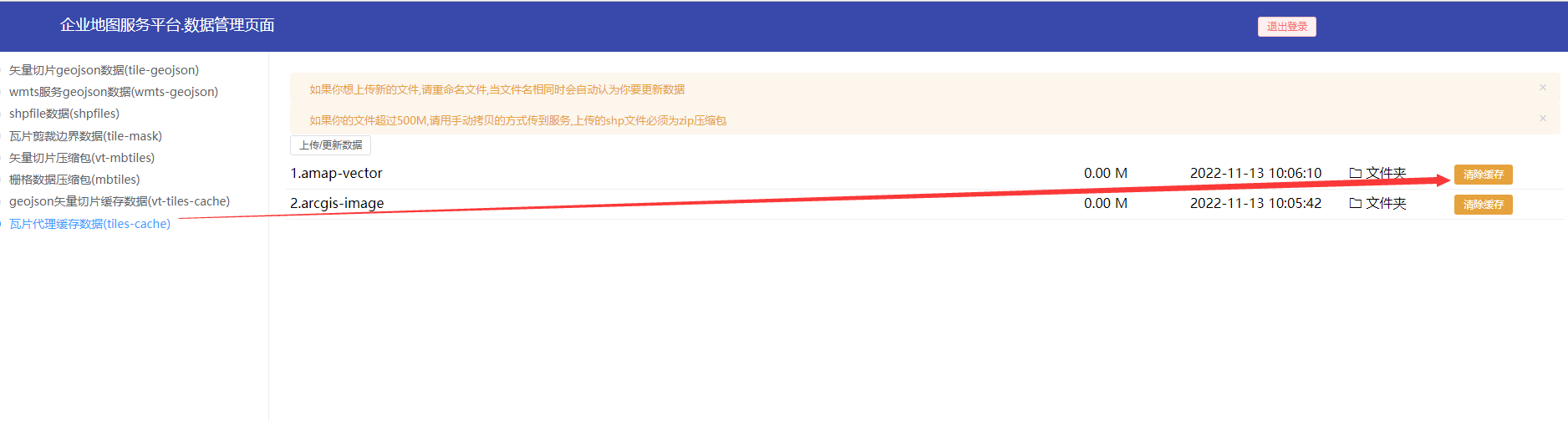
// [ip]:[port]/mapplat/common/tileproxy/amap-vector/{z}/{x}/{y}- 如果想删除缓存的切片, 可以进入
代理服务数据管理页面进行缓存清除
mapplat 怎样将4326/4490的瓦片重投影为墨卡托(3857)?
有时业务需要访问在线的切片, 但是切片是 4326/4490 投影的(比如天地图),但是你想要以 墨卡托的 方式加载(比如mapbox只能加载3857的切片), 这时你就可以使用该服务了
操作步骤:
- 配置
tilelayerMap里你需要代理的切片名字和地址
//serverconfig.js
//其他配置项
tilelayerMap: {
    ...,
    //  这里只做示范
    'tdt': 'https://t{s}.tianditu.gov.cn/vec_c/wmts?SERVICE=WMTS&REQUEST=GetTile&VERSION=1.0.0&LAYER=vec&STYLE=default&TILEMATRIXSET=c&FORMAT=tiles&TILEMATRIX={z}&TILEROW={y}&TILECOL={x}'
    //配置你的切片名字和地址
}
DANGER
注意配置的切片名字不能重复, 要做到切片名字的唯一性, 比如这样的错误示例
tilelayerMap: {
    //天地图的矢量底图
    'tdt': 'xxxxx',
    'tdt': 'yyyyy',
},- 重启 mapplat
node --max-old-space-size=80000 --tls-min-v1.0 index- 请求地址规则:
[ip]:[port]/mapplat/common/tiletransform/:layerName/{z}/{x}/{y}
| 参数 | 说明 |
|---|---|
| layerName | 就是配置的tilelayer代理的名字, 比如上面的 tdt |
// [ip]:[port]/mapplat/common/tiletransformy/tdt/{z}/{x}/{y}- 如果想删除缓存的切片, 可以进入
代理服务数据管理页面进行缓存清除
mapplat 怎样将多个瓦片服务合并?
 +
+  =
=
有时业务需要访问在线的多个切片, 为了减少前端的网络请求和压力(将多个瓦片合并成一张瓦片), 这时你就可以使用该服务了
操作步骤:
- 配置
tilelayerMap里你需要代理的切片名字和地址
//serverconfig.js
//其他配置项
tilelayerMap: {
...,
// 这里只做示范
'amap-image': 'https://webst04.is.autonavi.com/appmaptile?style=6&x={x}&y={y}&z={z}',
'amap-label': 'https://wprd02.is.autonavi.com/appmaptile?x={x}&y={y}&z={z}&lang=zh_cn&size=1&scl=1&style=8<ype=11',
//配置你的切片名字和地址
}DANGER
注意配置的切片名字不能重复, 要做到切片名字的唯一性, 比如这样的错误示例
tilelayerMap: {
    //天地图的矢量底图
    'tdt': 'xxxxx',
    'tdt': 'yyyyy',
},- 重启 mapplat
node --max-old-space-size=80000 --tls-min-v1.0 index- 请求地址规则:
[ip]:[port]/mapplat/common/tilemerge/:layerName/{z}/{x}/{y}
| 参数 | 说明 |
|---|---|
| layerName | 就是配置的tilelayer代理的名字, 比如上面的 amap-image , 多个切片服务请用 , 分割, 比如 amap-image,amap-label |
// [ip]:[port]/mapplat/common/tilemerge/amap-image,amap-label/{z}/{x}/{y}- 如果想删除缓存的切片, 可以进入
代理服务数据管理页面进行缓存清除
mapplat 怎样将 postgis里的表托管为矢量切片(vectortile)服务
- 在
/[path]/mappplat/serverconfig.js文件里配置你的数据库连接信息
DANGER
保管好你的数据库信息,不要随便泄漏,这里这样做的原因就是用别名来代替数据库连接信息
防止数据库信息泄漏,对外暴露的只是一个别名,真正的连接信息放在服务端了
   postgisMap: {
       //默认的我添加的数据库连接信息
       'defaultName': 'postgres://postgres:123456@localhost:5432/gistest',
       //添加你的数据连接信息,可以参考上面的信息配置
       'hellotest': 'postgres://[username]:[passowrd]@[ip]:[port]/[database]'
       // ...
},- 重启 mapplat
node --max-old-space-size=80000 --tls-min-v1.0 indextile地址的规则:
[ip]:[port]/mapplat/common/postgis/vt/[pgName]/[tableName]/[geoFiled]/{z}/{x}/{y}/[fields]pgName数据库名字, 就是你在postgisMap配置的,比如上面配置的hellotesttableName数据库里的表名, 比如wujianggridgeoFiled地理信息字段,默认geomfields需要携带的其他信息字段 默认*表示所有字段, 其格式col1,col2,col3,...., 比如id,name,fclass,osm_code
假设你的表叫
wujianggrid那么你的 tile 请求地址为:
[ip]:[port]/mapplat/common/postgis/vt/hellotest/wujianggrid/geom/{z}/{x}/{y}/name,id
mapplat提供postgis里表的查询和返回数据为(geojson)
- 在
/[path]/mappplat/serverconfig.js文件里配置你的数据库连接信息
DANGER
保管好你的数据库信息,不要随便泄漏,这里这样做的原因就是用别名来代替数据库连接信息
防止数据库信息泄漏,对外暴露的只是一个别名,真正的连接信息放在服务端了
   postgisMap: {
       //默认的我添加的数据库连接信息
       'defaultName': 'postgres://postgres:123456@localhost:5432/gistest',
       //添加你的数据连接信息,可以参考上面的信息配置
       'hellotest': 'postgres://[username]:[passowrd]@[ip]:[port]/[database]'
       // ...
},- 重启 mapplat
node --max-old-space-size=80000 --tls-min-v1.0 index地址请求规则:
[ip]:[port]/mapplat/common/postgis/querylayer?pgName=xxxx&tableName=xxxxpgName数据库名字, 就是你在postgisMap配置的,比如上面配置的hellotesttableName数据库里的表名, 比如wujianggrid
假设你的表叫
wujianggrid那么你的请求地址为:
[ip]:[port]/mapplat/common/postgis/querylayer?pgName=defaultName&tableName=wujianggrid
TIP
mapplat为可选项, 如果你的服务地址必须要mapplat, 那就加上,否则去掉, 和你部署mapplat的方式有关,默认mapplat是没有[mapplat]的,但是如果你是做一些反向代理是么的可能就需要加上去
mapplat 提供postgis表的空间查询(spatialquery)
- 在
/[path]/mappplat/serverconfig.js文件里配置你的数据库连接信息
DANGER
保管好你的数据库信息,不要随便泄漏,这里这样做的原因就是用别名来代替数据库连接信息
防止数据库信息泄漏,对外暴露的只是一个别名,真正的连接信息放在服务端了
   postgisMap: {
       //默认的我添加的数据库连接信息
       'defaultName': 'postgres://postgres:123456@localhost:5432/gistest',
       //添加你的数据连接信息,可以参考上面的信息配置
       'hellotest': 'postgres://[username]:[passowrd]@[ip]:[port]/[database]'
       // ...
},- 重启 mapplat
node --max-old-space-size=80000 --tls-min-v1.0 index地址请求规则:
[ip]:[port]/mapplat/common/postgis/spatialquerypgName数据库名字, 就是你在postgisMap配置的,比如上面配置的hellotesttableName数据库里的表名, 比如wujianggridlnglats经纬度串, 比如120,31;123,43;......
警告
该方法为post请求
假设你的表叫
wujianggrid那么你的请求地址为:
[ip]:[port]/mapplat/common/postgis/spatialquery
// 参数:
{
    pgName: 'defaultName',
    tableName: 'wujianggrid',
    lnglats: '120,31;122,32;134,44;.......'
}

//如果是圆查询

{
    pgName: 'defaultName',
    tableName: 'wujianggrid',
    lnglats: '120,31',
    radius: 100
}
TIP
mapplat为可选项, 如果你的服务地址必须要mapplat, 那就加上,否则去掉, 和你部署mapplat的方式有关,默认mapplat是没有[mapplat]的,但是如果你是做一些反向代理是么的可能就需要加上去
mapplat 怎样对瓦片(tile)进行剪裁
有时业务里需要对瓦片进行区域剪裁(比如瓦片的的范围很大, 但是只想显示某个区域), 可以用 mapplat 来代理剪裁下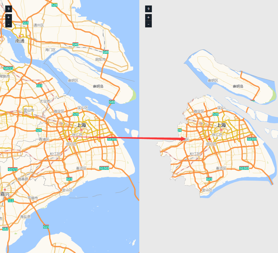
截图展现了本来是一个全国的瓦片数据,现在只显示上海的区域栅格数据
操作步骤:
/[path]/mappplat/serverconfig.js里开启 tilemask 选项
//serverconfig.js
//其他配置项

tilemask: true;- 重启 mapplat
node --max-old-space-size=80000 --tls-min-v1.0 index- tile-mask的请求地址规则:
[ip]:[port]/mapplat/common/tile-mask/:fileName/{z}/{x}/{y}/:epsg?tileUrl={tileUrl}
| 参数 | 说明 |
|---|---|
| fileName | 区域的geojson文件名 |
| epsg | 投影选项, 目前支持 3857 , 4326 , 如果你的瓦片数据是墨卡托投影的就填 3857 ,如果是经纬度投影就填 4326 |
| tileUrl | 需要代理的瓦片服务地址, 例如:https://webrd01.is.autonavi.com/appmaptile?lang=zh_cn&size=1&scale=1&style=8&x={x}&y={y}&z={z} |
- 准备好区域的
GeoJSON数据, 一般是个Polygon(MultiPolygon)数据 - 将
GeoJSON数据放到/[path]/mappplat/store/tile-mask文件夹下 或者使用代理服务数据管理页面进行数据上传 - 假设你的文件名字叫
上海.geojson, 那么你的请求地址为:
[ip]:[port]/mapplat/common/tile-mask/上海/{z}/{x}/{y}/3857?tileUrl=https://webrd01.is.autonavi.com/appmaptile?lang=zh_cn&size=1&scale=1&style=8&x={x}&y={y}&z={z}
DANGER
服务端匹配你的文件请求规则: 优先匹配 tile-mask 里的文件,如果匹配不到,将去匹配 shpfiles 里的文件
TIP
tileUrl参数的值就是你本来瓦片的服务地址,这里演示了加载高德矢量图资源
DANGER
目前仅仅支持标准的全球墨卡托和经纬度切片服务, 自定义切图参数的切片服务不支持
mapplat 怎样对瓦片(tile)进行反向剪裁
有时业务里需要对瓦片进行区域进行反向剪裁(挖洞), 可以用 mapplat 来代理剪裁下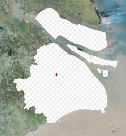
截图展现了本来是一个全国的瓦片数据,现在将上海的区域栅格数据挖掉
操作步骤:
/[path]/mappplat/serverconfig.js里开启 tilemask 选项
//serverconfig.js
//其他配置项

tilemask: true;- 重启 mapplat
node --max-old-space-size=80000 --tls-min-v1.0 index- tile-mask的请求地址规则:
[ip]:[port]/mapplat/common/tile-mask-rever/:fileName/{z}/{x}/{y}/:epsg?tileUrl={tileUrl}
| 参数 | 说明 |
|---|---|
| fileName | 区域的geojson文件名 |
| epsg | 投影选项, 目前支持 3857 , 4326 , 如果你的瓦片数据是墨卡托投影的就填 3857 ,如果是经纬度投影就填 4326 |
| tileUrl | 需要代理的瓦片服务地址, 例如:https://webrd01.is.autonavi.com/appmaptile?lang=zh_cn&size=1&scale=1&style=8&x={x}&y={y}&z={z} |
- 准备好区域的
GeoJSON数据, 一般是个Polygon(MultiPolygon)数据 - 将
GeoJSON数据放到/[path]/mappplat/store/tile-mask文件夹下 或者使用代理服务数据管理页面进行数据上传 - 假设你的文件名字叫
上海.geojson, 那么你的请求地址为:
[ip]:[port]/mapplat/common/tile-mask-rever/上海/{z}/{x}/{y}/3857?tileUrl=https://webrd01.is.autonavi.com/appmaptile?lang=zh_cn&size=1&scale=1&style=8&x={x}&y={y}&z={z}
DANGER
服务端匹配你的文件请求规则: 优先匹配 tile-mask 里的文件,如果匹配不到,将去匹配 shpfiles 里的文件
TIP
tileUrl参数的值就是你本来瓦片的服务地址,这里演示了加载高德矢量图资源
DANGER
目前仅仅支持标准的全球墨卡托和经纬度切片服务, 自定义切图参数的切片服务不支持
mapplat 怎样提供路线规划服务
有时在内网内无法使用外网的高德/百度等LBS的路线规划服务,这时可能需要自己搭建一个路线规划功能服务, mapplat 里可以直接搭建该服务
操作步骤:
/[path]/mappplat/serverconfig.js里开启 roadpath 选项
//serverconfig.js
//其他配置项

roadpath: true;- 重启 mapplat
node --max-old-space-size=80000 --tls-min-v1.0 index- 将路网的数据预处理成拓扑的json数据(这个数据处理过程需要我来处理), 必须要求把原始数据处理成对应的拓扑文件才行
联系方式
邮箱:mehudeyi@163.com
QQ:1390110605
- 将
json数据放到/[path]/mappplat/store/road-json文件夹下 或者使用代理服务数据管理页面进行数据上传
DANGER
处理好的拓扑json文件不是 GeoJSON 文件的, 请注意区分,不要混淆了
- 数据的请求接口地址
[ip]:[port]/mapplat/common/roadpath/:fileName/:fromlnglat/:tolnglat/:bufferradius
| 参数 | 说明 |
|---|---|
| fileName | json文件名, 比如 kunshanroad |
| fromlnglat | 起点经纬度, 比如: 120,31 |
| tolnglat | 终点经纬度, 比如: 120,32 |
| bufferradius | 查找起点终点的搜索的半径(M) , 后台服务要根据你传入的起点经纬度去路网上查找起始点的, 所以需要一个buffer范围来搜索下, 如果搜索不到起点或者终点, 可能需要你扩大搜索半径 |
- 假设你的文件名字叫
kunshanroads.json, 那么你的请求地址为:[ip]:[port]/mapplat/common/roadpath/kunshanroad/:fromlnglat/:tolnglat/:bufferradius
//举例
//http://localhost:9600/common/roadpath/kunshanroad/120.93420325594843,31.380125303120366/120.95308845777424,31.38050721461903/40- 其搜索结果的准确性和体验有以下要素决定
- 数据的完善性, 即原始的路网数据的完善性, 所以当原始的路网数据不完善时,其搜索的结果是很差的,甚至是错的等
- 更加优化的算法(我们会持续优化)
//简单的示例代码
const baseURL = 'http://localhost:9600';
fetch(`${baseURL}/common/roadpath/kunshanroad/${fromLngLat}/${toLngLat}/${bufferRadius}`).then(res => res.json()).then(json => {
    if (json.ok) {
        const coordinates = json.data.map(d => {
            const {
                x,
                y
            } = d.data;
            return [x, y];
        });
        const line = new YY.LineString(coordinates, YY.Style.formatLine({
            lineColor: 'red',
            lineWidth: 4
        }));
        layer.addOverlay(line);
    } else {
        alert(json.message);
    }
})- 返回的结果数据结构
{
    "ok": true,
    "message": "success",
    "data": [
        //拓扑节点信息
        {

            //节点所在的道路信息
            "properties": {
                "osm_id": "362212330",
                "code": 5114,
                "fclass": "secondary",
                "name": null,
                "ref": null,
                "oneway": "B",
                "maxspeed": 0,
                "layer": 0,
                "bridge": "F",
                "tunnel": "F",
                "altitude": 0,
                "name_2": "昆山市",
                "_color": "#bb11d6",
                "center": "(3:121.0027321253702,31.31666267522209,0)"
            },
            "id": 24312,
            "links": {},
            //节点自身信息
            "data": {

                "lineId": 3460,//道路的id
                "id": 24312,//节点ID
                "x": 120.9523649972982,//经度
                "y": 31.397359283009706,//纬度
                "mx": 13464355.681741402,
                "my": 3684462.0468256813
            }
        },
        {
            "properties": {
                "osm_id": "556194141",
                "code": 5115,
                "fclass": "tertiary",
                "name": "北门路",
                "ref": null,
                "oneway": "B",
                "maxspeed": 0,
                "layer": 0,
                "bridge": "F",
                "tunnel": "F",
                "altitude": 0,
                "name_2": "昆山市",
                "_color": "#bb11d6",
                "center": "(3:121.0027321253702,31.31666267522209,0)"
            },
            "id": 77819,
            "links": {},
            "data": {
                "lineId": 6328,
                "id": 77819,
                "x": 120.9523649972982,
                "y": 31.397359283009706,
                "mx": 13464355.681741402,
                "my": 3684462.0468256813
            }
        },

    ]
}
警告
该方案只是个备用方案, 如果你的项目环境允许外网的话,最好使用外网的在线LBS服务, 因为外网的LBS服务里还包含交通流量分析, 拥堵分析等, 而我们部署的这个服务仅仅是用来在解决内网无法使用在线LBS服务而已, 因为其和互联网是隔离的,所以无法提供这些数据服务
mapplat里查询polygon的地形数据
有时业务里需要做一些行政区的地形效果, 需要地形数据且是非规律的Polygon查询, 自己手写这个功能比较麻烦, mapplat 里做了这个功能的代理, 对地形数据瓦片做了剪裁和裙边 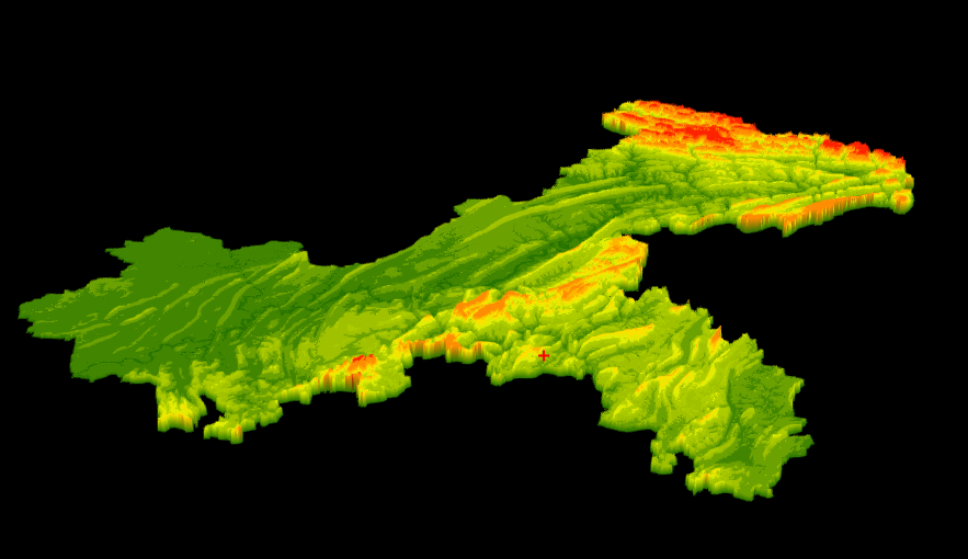
自己做的这个功能的话主要难点有:
- 不规则的polygon地形数据的剪裁
- 怎样识别返回图片的裙边
DANGER
该功能只能在互联网环境下使用, 如果在内网内使用需要离线rgb-tile数据瓦片
操作步骤:
/[path]/mappplat/serverconfig.js里开启 rgbtile 选项
//serverconfig.js
//其他配置项

rgbtile: true;- 重启 mapplat
node --max-old-space-size=80000 --tls-min-v1.0 index数据的请求接口地址
[ip]:[port]/mapplat/common/rgb-tile/query- post方法
- 参数为
gejson: 其必须是polygon feature
用axios请求举例:
   axios({
       method: 'post',
       url: '[ip]:[port]/mapplat/common/rgb-tile/query',
       data: {
           //该值必须是string
           geojson: JSON.stringify(feature)
       }
   }).then(res => {
       //返回的结果
       console.log(res.data);

});- 返回的结果数据结构
  {
    "ok":true,
    "message":"",
    "data":"",//PNG图片的Base64编码
    "bbox":[] //图片的经纬度范围[minx,miny,maxx,maxy]
  }
其中返回的图片是这个样子, 其是一个mapbox rgb 规范的图片
警告
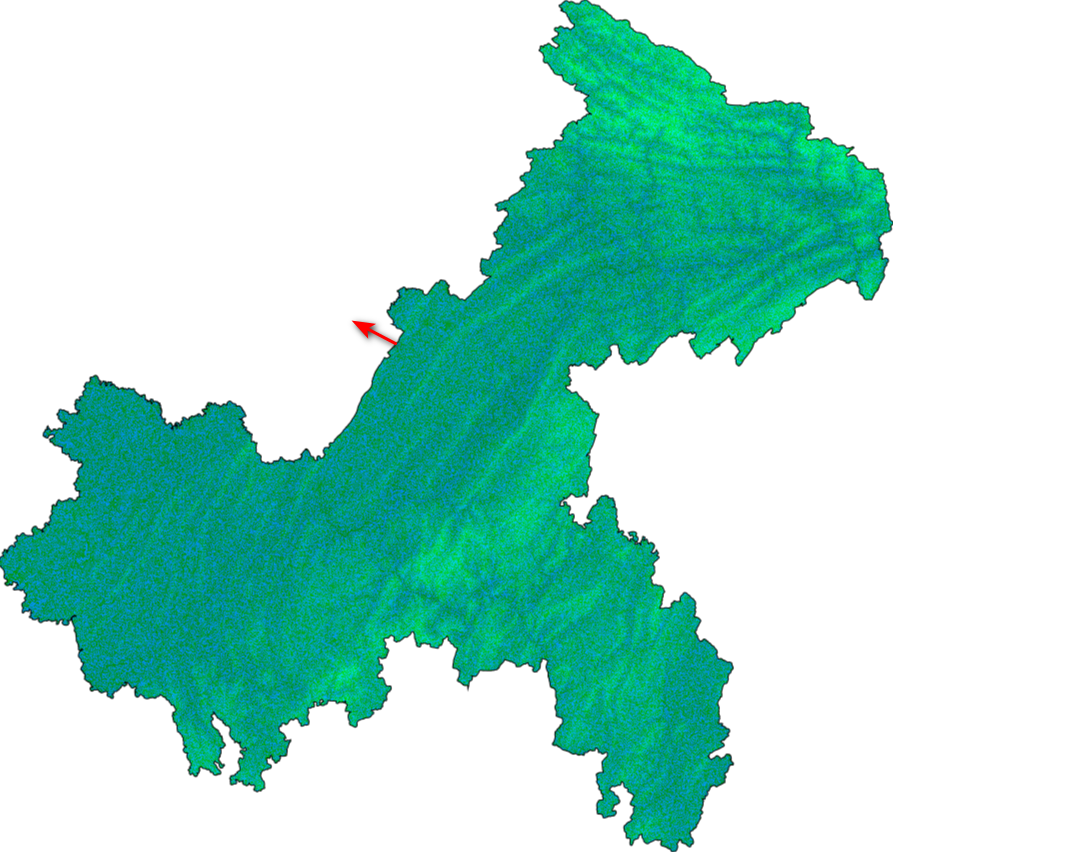
图片数据带了黑色的裙边, 在业务里使用时需要对黑色的裙边做特殊化处理, 之所以这么做是因为方便快速识别裙边, 当遇到RGB编码颜色是黑色rgb(0, 0, 0)时就认为其是裙边了
//举例代码:
const R = imgdata[i],
    G = imgdata[i + 1],
    B = imgdata[i + 2],
    A = imgdata[i + 3];
let height = 0;
//黑色的边框,你可以任意处理黑色边框,这里演示了将黑色边框处理成红色,也可以处理成透明的等
if (R === 0 && G === 0 && B === 0 && A > 0) {
    //黑色边框的地方height值为0
    imageData1.data[i] = 255;
    imageData1.data[i + 1] = 0
    imageData1.data[i + 2] = 0
    imageData1.data[i + 3] = 255;
} else if (A > 0) {
    //地形解码,根据RGB值求出高度值
    height = -10000 + ((R * 256 * 256 + G * 256 + B) * 0.1);
    height = Math.max(height, 0);
}
有了数据图片你就可以做些业务效果了,比如根据不同高度进行着色或者3D的效果 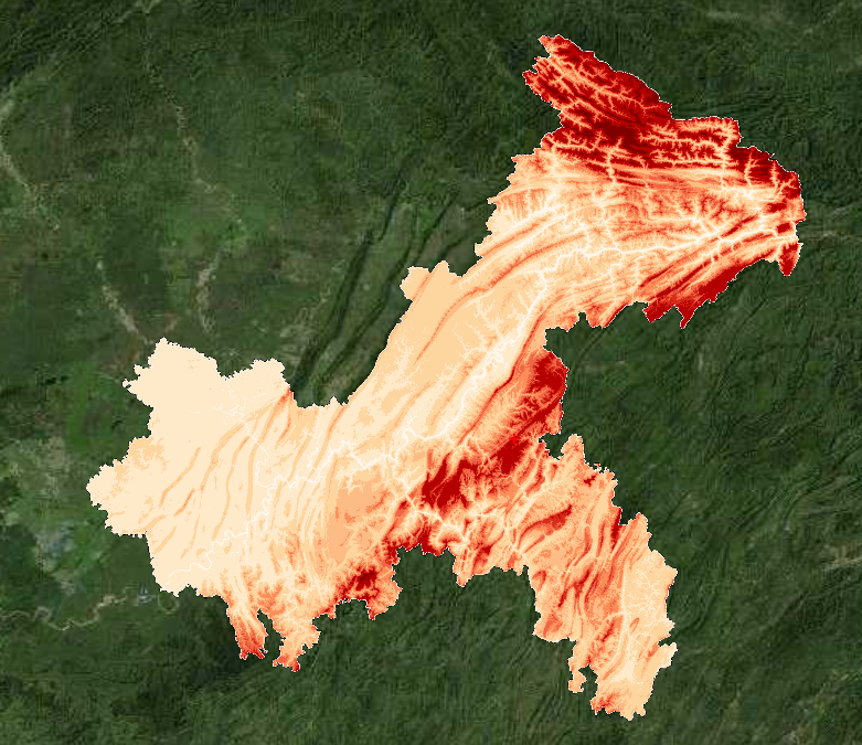
重庆市行政区根据海拔设置不同的颜色
重庆市行政区根据海拔设置不同的颜色3D版本
警告
接口只是提供一个数据接口, 拿到了数据图片怎样在业务里展示有你的业务系统来决定